|
Author
|
Topic: A New, 3D Interface Current Date/Time:
April 05, 2000 20:48:53
|
Slingshot
Warlord
From: Alberta, Canada
Registered: Jun 99
|
 |
posted March 08, 2000 22:57
  
|
 |

|
Here is an idea for a new way to see the Civ III map. It should look like a 3D globe. 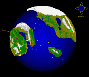 The controls would be something like:
- left-click and drag to rotate up/down/left/right
- right-click and drag to zoom in/out Some cities are in orbit. They are outlined in yellow. During zooming, elements would be representated by coloured dots (cities) or squares (units). Big cities would have more dots clustered together. After zooming, the map could regenerate cities and units to look more real. I would take Real-time zooming and 256 colours over a flat map and 16-bit. The benefit is that you don't need a second panel showing the world view... I found it wasn't too useful anyways, as the scale was funny. So any suggestions or ideas? |
Youngsun
Chieftain
From: Darwin,NT,Australia
Registered: Jan 2000
|
 |
posted March 08, 2000 23:59

|
|
|
Sligshot  It certainly looks good to me. Does it mean a farewell to the traditional square map? In ToT, there was small panel showing the globe spinning slowly at upper right side and if I click the globe it became the flat map again. But this was not a true representation of the Globe anyway(You are right) So how you going to define the basic land unit? Certainly not squares I reckon since their collection will be another hugh square.
Dots? how?(I'm not sure) or no more basic land unit at all?  Anyway good job slingshot. keep it up!
|
MidKnight Lament
Warlord
From: Melbourne, Australia
Registered: May 99
|
 |
posted March 09, 2000 00:16

|
|
|
I would have doubted the possibilities for this, but that pic looks good! After a bit more thought I guess it would be entirely possible that it could be done effectively.However, I'm one of these people who wants Civ3 to run on old systems so I don't have to upgrade (I've got a PII 233 so i should be right.) And even if I could run it, I don't want it to slow down come mid-to-late-game. I'd prefer to see it run smoothly and with little waiting, than get a 3D map. Besides, if you start having a 3D map, the customisers are going to have a fit unless they get a top class editor. So... it would be nice, and it'll happen somewhere down the track, but I'm not sure that it's for Civ3.
[This message has been edited by MidKnight Lament (edited March 09, 2000).] |
Slingshot
Warlord
From: Alberta, Canada
Registered: Jun 99
|
|
posted March 09, 2000 15:08
|
|
|
You Austrialians are all right!Apolyton should be a medal for good feedback, and it should be called the "Spirit of Those Guys Downunder" Award. Depending on the resolution, you should be able to fit polygons on the surface of the globe (pentagons, I think). Maybe someone can help me here, but I believe the biggest processing obstacles to real-time zooming are: - Just how "real-time" you want it (eg. smooth, with lots of regenerations versus choppy) - The number of colours - The resolution of surface-bound objects One cool artistic trend is that Art-Deco look. Here, units would be mainly black and sepia (a brownish-yellow). A movie like GATACA, or a game like Fallout are examples of the style. Various highlights could be added that would use more primary colours. I think that this art syle could help optimize zooming, while keeping the art looking good. Another option is simply to have objects represented by coloured blocks. All magnifications will look this way except for the Standard View. The magnification of the Standard view would be similar to what a Civer is used to. The best part about a map on a sphere is how the relief (changes in elevation) would look. Imagine your unit on the top of a mountain, with its field of view larger than if it were in a valley. And imagine that field of view being gradually darker with distance. This would really give Civ more of a 1st person, RPG feel. I don't see why a lot of these effects could not be done on a Pentium II system! Unexplored parts of the globe could be outlined with dotted polygons. Imagine what a space launch would look like!
|
MidKnight Lament
Warlord
From: Melbourne, Australia
Registered: May 99
|
|
posted March 09, 2000 17:16
|
|
|
Thanks for the praise, Slingshot  There's no doubt that 3D graphics would be cool. Again, after reading what you just wrote, it sounds even better. And if they can do it and keep the game fluid and fast without it being on a super-system, then I'm all for it. No doubt. I'm just not sure that they can. Although the release will be far away yet, I'm thinking that perhaps they may have gone too far into their design to choose 3D now anyway. Unless they already have  Nice, but probably not feasible. |
Slingshot
Warlord
From: Alberta, Canada
Registered: Jun 99
|
|
posted March 09, 2000 18:49
|
|
|
It is ideas like this that made me want to post a Civ IV section.Maybe we could call it something else, like Super Civ ideas. You never know. Firaxis probably won't put it in Civ III, and Activision definitely won't put it in CTP II, but maybe another company will create a civ-like game that will. Maybe DanQ or MarkG could tell me what they think about a SuperCiv - Ideas thread. If they think it is stupid or irrelevant, I would like to hear that, too.
[This message has been edited by Slingshot (edited March 09, 2000).] |
Dienstag
Chieftain
From: Sinking Spring, PA, USA
Registered: Feb 2000
|
 |
posted March 09, 2000 23:16
|
|
|
I really like the idea of a 3D world, but it's easy to forget that geometry only lets us get away with so much.I was going to present a long impromptu geometry lesson, but hopefully you'll just take my word for it that there's no _simple_ way to make anything like a sphere out of polygons. Yes it can be done, but at the expense of being very hard to program and not very fun to play. If you really want proof of this, just say so and I'll do my best to show why. It seems to me - and if anyone has a better idea I'd love to hear it - that we can't have anything like a spherical world based on any reasonable arrangement of polygons. The only way to have a spherical world then - and in this case it could be perfectly spherical - would be to do away with the polygons altogether. (Based on something someone who's name I forget said, I think they may have done this in the game Populous. Sorry haven't seen it). Spherical world without polygons: pros:
-extremely realistic
-looks really cool cons:
-hard to program, entire game concept re-worked
-probably requires really good computer to do it justice. Can anyone else think of more pros and cons for the polygonless spherical world? Can we really give up on a polygon based spherical world, or is it just me? Hope this adds to the discussion... -Dienstag |
Gord McLeod
Settler
From: Georgetown, Ontario, Canada
Registered: Mar 2000
|
|
posted March 09, 2000 23:40
|
|
|
The game you're thinking of is Populous - The Beginning. It uses a spherical planet and does so quite well - it would be great to see something like it for Civ3. There is terrain variation though, it's not just a pure sphere without heights or depths. To use something like this would change the way the game played, though... it's hard to tell just by playing the game, but it seems to me that they may have used a coordinate point system on the surface of the world rather than any sort of grid-like arrangement. Something similar would have to be done for Civ, I think. |
Slingshot
Warlord
From: Alberta, Canada
Registered: Jun 99
|
|
posted March 10, 2000 00:10
|
|
|
Thanks for the feedback!Dienstag: We can crunch the math if you want. But think of a soccer ball. It has a surface made up entirely out of pentagons. Take a sphere and look at it from the North pole. That sphere, of course, is now a circle. The circle can be aproximated by any type of polygon. We now have lines of longitude for a grid. Now if we look at the sphere from the equator, it is possible to draw lines of latitude in the same way. Of course, a perspective must be generated, but this could be simplified by allowing only one light source directly behind the line of sight. This way, the center of the sphere is highlighted and the edges are increasingly dark. I wonder if there is a programmer out there with experience in 3D rendering. My own experience is on AutoCAD, and it is quite limited. I am sure that there are many sub-routines out on the net for this sort of thing. I also think a lot could be done with pasting landscape graphics on each tile, and using some creative shading. |
Slingshot
Warlord
From: Alberta, Canada
Registered: Jun 99
|
|
posted March 10, 2000 00:12
|
|
|
For comparison's sake:Does anyone have the system requirements for these games: Populous - The Beginning
Homeworld That might help us see what the pros think. |
Dienstag
Chieftain
From: Sinking Spring, PA, USA
Registered: Feb 2000
|
 |
posted March 10, 2000 00:35
|
|
|
Wow, I've never posted in the same thread twice in one night before. There may be something to this....I don't know about you guys, but every "regular" soccer ball (I've seen a bunch of weird ones recently) is a combination of pentagons AND hexagons. Check me, but I'm pretty sure I'm right. This would make things harder, but even if they were all pentagons you'd only have what 20, 30 of them tops? Playing a game with only 20-30 spaces wouldn't work, and you can only cut up pentagons into triangles so that's not much help either. See what I mean? As to Slingshot's idea with the lines of latitude and longitude: I think I see what you mean, but if I do it means having lots of different sized polygons. Am I right? Wouldn't the spaces get smaller toward the poles, and wouldn't this make things like movement unrealistic? ...just trying to figure this out. Also, I don't think it will be much of a problem rendering the 3-D. The bigger problem will be having something to render. Thanks for the info on Populous. That sounds like a neat way Civ III could go if Firaxis is willing to totally start fresh. Slingshot-
I'm not entirely sure what math it was you were offering to crunch. Whatever it is, if you've got nothing better to do, go for it! -Dienstag |
Gord McLeod
Settler
From: Georgetown, Ontario, Canada
Registered: Mar 2000
|
 |
posted March 10, 2000 01:26
|
|
|
Wouldn't you know it? I just happen to have the boxes for both Populous - The Beginning and Homeworld right here. How very convenient. ;)Populous:
P133 (recommended: 200 Mhz or higher)
100 MB HD space free (recommended: 110+)
16 megs RAM (recommended: 32 megs)
4x CD-ROM or better (recommended: 8x or faster)
Mouse, keyboard
Supports D3D on a variety of 3D cards, which they recommend using. Homeworld:
PII 233 (recommended: PII 350)
32 megs RAM (recommended: 64 megs)
100 megs HD + 50 megs perm. swap (recommended: 400 megs full install)
4X CD-ROM
4 meg PCI video card (recommended: 12 meg 3D accelerated video card) |
Thunderfall
Chieftain
From: Civilization Fanatics Center
Registered: b.02-15-99
|
 |
posted March 10, 2000 01:55
|
|
|
It's a good idea. With that we could even put some satelites in the orbit and just point and click to control them using that globe screen. :-)Maybe civ3 should allow players to build satlelite launch center in civ3... Such center would enable players to launch spy satelites, weather satlelites, etc. And if they introduce natural disasters in Civ3, satelites could monitor the earth and predict (some)disasters in advance, thus reducing the amount of damage the disasters. What do u think? ------------------
=-=-=-=-=-=-=-=-=-=-=-=-=-=-=-
Thunderfall
Civilization Fanatics' Center
http://members.xoom.com/wilsong
-=-=-=-=-=-=-=-=-=-=-=-=-=-=-=- |
Slingshot
Warlord
From: Alberta, Canada
Registered: Jun 99
|
|
posted March 10, 2000 13:48
|
|
|
In my opinion, people really want an improved experience. Often we look at creating more realism through more sophisticated rules. I think that Publishers feel pressure to make better graphics, because it is easier to sell images.Hopefully we have both here. Working on a globe could look cool, and also add some functionality (like perspective). |
korn469
Prince
From: the dark wastelands of apathy
Registered: Apr 99
|
|
posted March 10, 2000 15:00
|
|
|
Slingshot,i loved your little globe graphic! if they ever make a civ4 globes are a must...i think that this would be a much more realistic system, all i wonder if how does it look when you zoom in? would it be flat? i think it needs to be flat when you zoom in if that is possible korn469 |
Slingshot
Warlord
From: Alberta, Canada
Registered: Jun 99
|
 |
posted March 11, 2000 23:31
|
|
|
To simplify the math:Forget polygons! All we really need to do is mark the globe with points. At each point you would put a terrain icon. The land-based icons could be made with fuzzy edges so that they blend together. The ocean icons would be solid all the way to the edge. Each icon could have an octagon shape. Points are easier to keep track of, since each point can be specified by:
- radius (from the center of the planet)
- angle from the north pole (0 - 2*pi radians, or 0 - 180°)
- angle from the "front" of the globe (I think it is called the Prime Meridian). This should make a sperical planet more processor-friendly. |
Dienstag
Chieftain
From: Sinking Spring, PA, USA
Registered: Feb 2000
|
|
posted March 12, 2000 07:48
|
|
|
Slingshot-
Isn't putting a terrain icon (as you suggested, an octagon) at each point kinda like the polygon thing you just said to forget? I understand that the icons blending into each other will help things, but I think we still have pretty much the same problem.As you said, each point on your map has three coordinates (essentially altitude, lattitude, and longitude). Let's say a unit is at one of the points, and that the unit can move but only onto an adjacent point. This is the heart of the problem: If the points are arranged so that there is always a point to the north, south, east, and west, then the points get closer to each other at the poles, so that it takes the same amount of movement points to get around earth no matter what lattitude you're at. Then we have a cylindrical world that just "looks" like a sphere. Whats worse, this is what happens if the points are arranged in _any_ reasonable pattern that would make movement easy. If, on the other hand, you arrange the points so that they are all about the same distance from each adjacent point, then you get a really messed up map (ever look at the little bumps on a basketball?), such that just moving a unit becomes obscenely complicated. If we really want a sperical world with logical movement, I suggest the following:
1. forget polygons
2. forget points (as a basis for movement)
3. use the unit's actual coordinates This may seem really weird, but I don't know any better. This would answer the movement question; just give the unit a direction and there it goes. Terrain could be distributed by points (assuming points evenly spaced, thereby making a neat map), but the affect of these "terrain points" on movement would be subtle. A unit is never really on a space, but for the purposes of movement we can consider it in the terrain of the nearest "terrain point." The distance the unit can travel in any direction is based on the MP's of the unit, and the coordinates and movement penalty factors for a few Terrain Points. The math would be somewhat difficult (just spherical trigonomtery, nothing the computer couldn't handle easily), so the player would never be certain how far they could get. This is just an extension of the current Civ II system of randomly being (un)able to enter the forest on your last MP, except it's less random so after a while the players will have a pretty good idea. This idea needs a lot more developement before anything productive will come out it. I hope this idea isn't altogether dumb and that I've described it somewhat well. I'm not convinced of either at this point. I think its the best bet yet for a spherical world, but I'd really like your input. Also, does anyone know _exactly_ what Populous did, and how? That would be nice to know. Dienstag |
Gord McLeod
Settler
From: Georgetown, Ontario, Canada
Registered: Mar 2000
|
|
posted March 12, 2000 16:03
|
|
|
I think the basic problem is that you're trying to combine elements of a grid-based movement system onto a 3D sphere, and that's simply not going to work. Populous didn't even try - they used, as far as I can tell, a pure coordinate system. There were no tiles on the world, it was a 3D object with heights and depths and elevation. The way I remember it playing was, if the characters were moving in a direction, they simply moved over the surface of the ground at whatever elevation they were on - steep elevations caused an increase or decrease in speed (depending on whether they were going up or down).Different terrain types in Civ could simply penalize movement speed (ie, you'd get through a forest no problems, but you'd see your units moving more slowly.) You basically just take your start coordinates, end coordinates and movement rate, and off they go... the path they take and the movement rate along that path may vary due to geographical considerations, but if you know the rough path they'd be taking you'd be able to estimate the time it will take them to arrive, as you'd be able to see the intervening terrain and estimate how it'll affect their speed. |
LightEning
Prince
From: Rantsila/Oulu/Finland
Registered: Oct 1999
|
|
posted March 12, 2000 16:13
|
|
|
Has anybody played UFO - Enemy unknown (aka X-Com - UFO defense)? The geoscape view was a globe, apparently made of polygons, the units were simple points and the system looked great. The map was easy to read and the globe was a real sphere. And the best thing in it: It easily worked quickly with 386-40 and no math co-processor. Now almost all have pentiums. So, I don't think the globe would be so heavy. |
Dienstag
Chieftain
From: Sinking Spring, PA, USA
Registered: Feb 2000
|
|
posted March 14, 2000 07:51
|
|
|
Well, I haven't seen X-Com - UFO Defense, but it sounds neat.Thanks Gord Mcleod for that last post. It gives me the best idea yet for how Populous works, and it says pretty much what I tried to say, only much better. Assuming the X-com thing is some version of the others, this leaves us with two basic methods of making a map: 1. Grid-based (cannot be spherical)
2. Coordinate-based (I'm guessing can be whatever shape you want - in this case: spherical) So what would it take to make Civ III on a coordinate-based map? The movement question seems to have been answered. I suggested a means of creating landscape above, but that's open to debate. What happens to the city radius? What happens to special resource distribution? What about roads and railroads? What about all the other things that currently depend on a grid-based system but I can't remember them right now? Dienstag |
Slingshot
Warlord
From: Alberta, Canada
Registered: Jun 99
|
|
posted March 14, 2000 12:09
|
|
|
As far as Civ is concerned, there is no difference between a grid- and coordinate-based system. In each, all units/cities/tiles have a set of coordinates to call their own. Recall that you could find where certain units were from the city screen if they weren't at home. The computer gave their location by two coordinates.The only trouble is for an artist to make certain that the tiles mesh together in an appealing manner. Perspective must also be considered. |
MidKnight Lament
Warlord
From: Melbourne, Australia
Registered: May 99
|
|
posted March 14, 2000 18:55
|
|
|
You're probably right from a graphics perspective, but I think you'll find that once you have a think about it, there'll be tonnes of ways this affects game concepts. I'm not saying it couldn't be done, but it's a radical change, and it will mean that many things will be upended.I realise that you are trying to make large changes for the better, but if you wanted a safer option, I think you'd be better to stick with a hex based system. Sorry if I've dampened any spirits. - MKL |
Slingshot
Warlord
From: Alberta, Canada
Registered: Jun 99
|
 |
posted March 15, 2000 17:03
|
|
|
Bad post. See below for the right stuff!
[This message has been edited by Slingshot (edited March 15, 2000).] |
Slingshot
Warlord
From: Alberta, Canada
Registered: Jun 99
|
|
posted March 15, 2000 17:03
|
|
|
MKL-You are a top-quality Apolytoner! Thanks for the constructive criticism. I found an interesting site (made by hippies, I think) that talks about how to make geodesic domes (and two domes make a sphere!) It can be reached at www.desertdomes.com Note how six triangles make for a cool hexagon! Check out their links for more information on the math. Actually, I've been putting my efforts on the CTP2 - General and Dino fronts. There I have had some very interesting, um, interviews with members of Firaxis and Activision. They're titled "An Ode to Firaxis/Activision" |
Victor Galis
Prince
From: Decatur, GA USA
Registered: Jul 1999
|
|
posted March 15, 2000 21:29
|
|
|
I think on a 3D world has too many problems. The terrain features, wcan have coordinate features, but e=they also need size... and it gets complicated, you can't just call them a circle or something simple because it overlaps. UNits, cities, and all such have sizes, and rendering them as simple polygons just won't work. More later... but in any case this idea is definitely in the realm of civ4 discussions because it needs to be fleshed out. |
Slingshot
Warlord
From: Alberta, Canada
Registered: Jun 99
|
|
posted March 15, 2000 23:32
|
|
|
Victor,I have tried to start a Civ 4 thread, and it didn't go anywhere. It would be great if somebody could start one on this buletin board - or at least tell me why they won't do it. Now would be a great time to say "Believe in Firaxis. They're creative and resourceful, and they probably end up surprising us!" But given the distinct silence, I don't feel so generous. "New thinking, new hopes, new World... Time for a Big, Huge Gaming World to take hold!"
(And in my opinion, it should be 3D ) |
korn469
Prince
From: the dark wastelands of apathy
Registered: Apr 99
|
|
posted March 16, 2000 05:08
|
|
|
slingshoti think that the only reason people do not want to discuss civ4 is because civ3 is a year away so here is a civ4 time table April 2001: Civ3 released
December 2001: Civ3 expansion pact released
September 2002: SMAC2 announced
March 2004: SMAC2 released
October 2004: SMACX2 released
December 2004: Civ4 announced
Febuary 2006: Civ4 cancled because of the demise of TBS games
July 2006: CivOnline announced
January 2007: CivOnline open beta test begins
September 2007: CivOnline released
ok of course my time table isn't correct...but i doubt that civ4 is going to be hitting store shelves any time soon...and when civ4 does finally go into a prototype phase who know what form it will take... ------------------
The OpenCiv3 website
korn469 |
Slingshot
Warlord
From: Alberta, Canada
Registered: Jun 99
|
 |
posted March 16, 2000 12:28
|
|
|
Heh heh, I like the timeline! But how about this?
March 2000: CivNextGen forum opened on Apolyton
August 2000: Dinos released. 
September 2000: Due to the inspiring work of Apolyton, Big, Huge, Next Generation Civ Announced
October 2000: CTP2 released.... patch pending
April 2001: Civ3 released - people are dissapointed because it's got dinosaurs in it
September 2002: SMAC2 announced - Alien factions look oddly like dinos
June 2001: SMAC2 cancelled because the Next Generation of Civ is right around the corner
November 2001: CTP2 patch is almost complete !
August 2003: Ideas from CivOnline are incorporated in CivNextGen. The world is taken by storm. Free vacations and promotions are given to all Apolytoners!
|
Urban Ranger
Prince
From: The City State of Noosphere
Registered: May 99
|
|
posted March 18, 2000 10:54
|
|
|
quote:

Originally posted by LightEning on 03-12-2000 04:13 PM
Has anybody played UFO - Enemy unknown (aka X-Com - UFO defense)? The geoscape view was a globe, apparently made of polygons, the units were simple points and the system looked great. The map was easy to read and the globe was a real sphere. And the best thing in it: It easily worked quickly with 386-40 and no math co-processor. Now almost all have pentiums. So, I don't think the globe would be so heavy.
|
Yeah, I played UFO: Enemy Unknown and it is way cool. Even though I was watching the Geoscape like a hawk, I can't recall it being a grid system. Seemed like a coordinate one to me. |
Urban Ranger
Prince
From: The City State of Noosphere
Registered: May 99
|
|
posted March 18, 2000 23:17
|
|
|
I think I have got it.When you try to make a sphere out of regular polygons, it doesn't work. It seems to me that we were thinking backwards. What we should be doing is to project a grid of regular polygons on a spherical surface. That should work. Imagine a cube of clear jelly measuring 10 units on each edge. Inside the clear cube is a purple jelly sphere 10 units in diameter. Impose a 10 x 10 square grid on each face of the cube. Make cut marks 1 unit deep along the grid lines. Remove the clear jelly. Now the cut marks left on the purple jelly sphere is the projection of a square grid on a spherical surface. (Hm, I feel that something is missing here, what is it?) It is just like etching out longitude and latitude lines on a sphere. I don't think a hex grid could be projected in such a way to completely cover the surface of a sphere. Please correct me if I am wrong. |
The Mad Viking
Chieftain
From: Toronto, Ontario, Canada
Registered: Feb 2000
|
|
posted March 22, 2000 17:07
|
|
|
The problem is that every tile must be identical for terrain and unit gif mapping to work.Geodetic domes are made of subtly varied triangles and cannot do this. OK, here's how it could work. You start with an icocehedron. No, its not what happens to your head after drinking too much. Its a 21 sided prismatic solid in the general shape of a sphere, formed entirely of equilateral triangles. (This is the shape of those big funny dice in D&D) You map onto each triangle as many hex-tiles as you want. Because hex tiles form a perfect equilateral triangle, excepting that the three "lines" aren't perfectly straight. These triangles would be mini-maps in themselves. To get a good size globe you would have about 240 hexes along one side of the triangle. This would give you about 10000 tiles, like a 80 x125 grid. You would have 21 selectable views, which you could scroll between. Each would be straight "down" onto one "triangle, with a slightly oblique but very legible view of the six adjacent triangles. You could easily rotate your view in any of 3 directions, and quickly scroll around to the opposite side or the globe. At the interface between two triangles, you would have only prependicular movement from your "own" triangle across the interface to the corresponding hex on the other triangle. Some graphical work here, but the geometry works. Not as spherical as anyone would like, but lets you have correct movement, and send an ICBM over the ice cap if you want. BTW, I don't believe there is such thing as a computer map without "tiles." Call them points or co-ordinates, they act as tiles. They are all mathematically defined relational space. Some programs just conceal them better than others. To try to emulate a gridless world at all you would need a ten by ten sub-coordinate system for each current civ "tile" - 1,000,000 points for your computer to track. For what? Is what I'm trying to say at all understandable?
[This message has been edited by The Mad Viking (edited March 23, 2000).] |
Adm.Naismith
Warlord
From: Milano - Italy
Registered: Oct 1999
|
|
posted March 22, 2000 17:52
|
|
|
Sound interesting, but you lost me somewhere on the visualization part (it's almost midnight here and I have a bad cold, so my brain is not at full steam).Anyone with a picture to help me visualize the idea? ------------------
Adm.Naismith AKA mcostant
|
Curumbor Elendil
Warlord
From: New Haven, CT, USA
Registered: Nov 1999
|
 |
posted March 22, 2000 18:37
|
|
|
I like the concept of a spherical world; in fact, I was going to post something about it here but then I saw this thread. It would require an alteration of some game concepts, if we were to have a true sphere without squares or other polygons.Movement points could be expressed in terms of miles or kilometers along the surface. City radii would actually be just that, radii of perfect circles. Resources would be continuous, rather than discrete. For example, a city could have 28239.9 hectares of forest, 1000293.6 hectares of grassland, and so on. Production of food and units and improvements would rely on a function translating hectares of these resources into grain storage and construction capacity. This function could actually be estimated by running regressions of population and economic growth on various climactic and geographical conditions of world regions. This would ensure realism. It would be very complex, to be sure, but given that turn-based strategy isn't very demanding on computer systems anyway, surely we can afford this kind of detail and complexity. We're not talking about a 3-D accelerated action game like Descent 3. ------------------
Curumbor Elendil
jason.sorens@yale.edu
ICQ 56126989 [This message has been edited by Curumbor Elendil (edited March 22, 2000).]
[This message has been edited by Curumbor Elendil (edited March 22, 2000).] |
The Mad Viking
Chieftain
From: Toronto, Ontario, Canada
Registered: Feb 2000
|
|
posted March 23, 2000 12:54
|
|
|
CE, good ideas.If we use a sphere, all terrain boundaries would be defined by coordinates. You would need at least 3 coords to define a region on the surface of your sphere, which the computer could then calculate the area of. Good thing it could, because I couldn't! Units and cities locations would have to be defined by a point (a centre-point if you will) on the surface of the sphere. You still must define an minimum increment for your units in order for the logic to work. (e.g. for the computer to know that two things are in the same location) Movement would have to be iterative for a TBS game, that is, you click on a location and it tells you how much of your movement point allowance it would take before you commit to the move. I say this because having missiles fall short or planes run out of fuel takes the fun out of the game. For that matter, I want to know if a ground unit can get to a city in the current turn or not to plan my strategy. How do you define the relationship between multiple points on the surface of a sphere? Latititude and longitude are comprehensible to us, but are awkward models for calculation the distance between two points, because the distance between two lines of longitude vary as your latitude changes. Calculations can be done on distance, but you still end up with as many points (possible locations) circling the north pole one degree south of it as you do along the equator. So you have 360 points about a mile apart located 70 miles south of the north pole, and 360 points 70 miles apart along the equator. Now I'm really curious as to how the coordinate based games on spheres do this! |
Curumbor Elendil
Warlord
From: New Haven, CT, USA
Registered: Nov 1999
|
|
posted March 23, 2000 16:21
|
|
|
Yes, it seems as if the number of points should recede toward the poles. Now, what would be the problem with making each point equivalent to a pixel on the computer screen? That would be very precise, pretty much avoiding the problems associated with making a near-sphere out of polygons, and would also seem to solve the problem of distances toward the poles. To my simple understanding of it, anyway.------------------
Curumbor Elendil
jason.sorens@yale.edu
ICQ 56126989
|
Gord McLeod
Settler
From: Georgetown, Ontario, Canada
Registered: Mar 2000
|
|
posted April 05, 2000 20:48
|
|
|
quote:
Originally posted by The Mad Viking on 03-23-2000 12:54 PM
Now I'm really curious as to how the coordinate based games on spheres do this!
|
Populous didn't worry about it. There were no north/south poles on the planets you played on, or at least, there was no difference in climate to indicate the poles. No equatorial bands, no ice caps. | |

 Apolyton Civilization Site Forums


